|
 Air Air
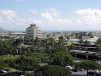
Located on the western end of Honolulu proper, Honolulu International Airport (HNL) is the principal aviation gateway to the state of Hawaii.
Highways
Four freeways serve Honolulu:
Interstate H-1, which, coming into the city from the west, passes Hickam Air Force Base and Honolulu International Airport, runs just north of Downtown and continues eastward through Makiki and Kaimuki, ending at Waialae/Kahala. West of the city proper, H-1 connects to Interstate H-2 from Wahiawa and Interstate H-3 from Kaneohe.
Interstate H-201also known as the Moanalua Freeway and formerly numbered Hawaii State Rte. 78connects two points along H-1: at Aloha Stadium and Fort Shafter. Close to H-1 and Aloha Stadium, H-201 has an exchange with the western terminus of Interstate H-3 to the windward side of Oahu (Kaneohe). This complex of connecting ramps, some directly between H-1 and H-3, is in Halawa.
Other major highways that link Honolulu proper with other parts of the Island of Oahu are:
Pali Highway, State Rte. 61, crosses north over the Koolau range via the Pali Tunnels to connect to Kailua and Kaneohe on the windward side of the Island.
Likelike Highway, State Rte. 63, also crosses the Koolau to Kaneohe via the Wilson Tunnels.
Kalanianaole Highway, State Rte. 72, runs eastward from Waialae/Kahala to Hawaii Kai and around the east end of the island to Waimanalo Beach.
Kamehameha Highway, State Rte. 99, runs westward from near Hickam Air Force Base to Aiea and beyond, eventually running through the center of the island and ending in Kaneohe.
Like most major American cities, the Honolulu metropolitan area experiences heavy traffic congestion during rush hours, especially to and from the western suburbs of Kapolei, Ewa, Aiea, Pearl City, Waipahu, and Mililani. Land for expanding road capacity is at a premium everywhere on Oahu.
Public transportation
Established by former Mayor Frank F. Fasi, Honolulu's public transit system has been twice honored by the American Public Transportation Association bestowing the title of "America's Best Transit System" for 19941995 and 20002001. Oahu Transit Services' "TheBus" operates 93 routes with a fleet of 525 buses.
Currently, there is no fixed-rail mass transit system in Honolulu. However, in 2004, the City & County of Honolulu and the State of Hawaii approved development of an action plan for a fixed rail mass transit system to be built in several phases. The initial line could link Kapolei in West Oahu to UH Manoa. Several attempts had been made since the 1980s and 1990s to construct a fixed rail mass transit system but stalled during Honolulu City Council hearings. However, on December 22, 2006, Honolulu City Council approved a fixed-guideway system that will accommodate either rail or buses, that runs from Kapolei in West Oahu to UH Manoa, with a spur into Waikiki.
Also in 2004, construction had started on a bus rapid transit (BRT) system using dedicated rights-of-way for buses. The system, proposed by former Mayor Jeremy Harris, was expected to link the Iwilei neighborhood with Waikiki. However, current Mayor Mufi Hannemann has largely dismantled the BRT system and deployed its buses along other express bus routes.
|